Feeds:
Posts
Comments

Posts Tagged ‘Maps’

In today’s news, a new world map was endorsed by the UN and wow it really changes the perspective. I was really accustomed to the old map, the warped map that tried to fit a 3D image on a 2D space. Mercator Map! I know most people must be. I bet my friend Russell Kirkpatrick would be excited by this. Equal Earth Cartographic Projection! Now Greenland is smaller and Africa is bigger and the emphasis is not on Europe and the USA now. I really like it and I am so surprised how different it looks. Who knew maps were political instead of being objective. I suppose with borders moving that’s political but this view of the world we have had has been around for nearly 500 years. Of course, the USA did not vote for the change and spoke against.

Can we say it’s just a map? I considered them neutral things but I recall one map workshop Russell did and he showed all kinds of different maps, just as one modeled on the cross/crucifix and that was a very church map that had the church in the centre of town. And different shaped maps. Also, Russell said maps were very male oriented because males and females navigate differently. I always thought I was good at reading maps and navigation back in the days before GPS and phone guidance. However, I go the wrong way a lot just getting out of a lift. I also couldn’t tell you where north was most of the time.

About twenty years ago, I was looking for a building one morning, my first day on an audit. I could not find this particular street. I asked people and they didn’t know and it was the most prominent street in Canberra. But I did not know that. I rang a guy I knew and he said go to this corner and face north. I was like where is north. Mind you by then I was hot, sore footed and very late so was getting beyond rational. I did find it in the end, but if someone had said, in the building with the duty free shop, I would have found it first up! Hahaha. So maybe Russell was right and it’s a sex differentiation thing.

But yay for Africa being big.
Read Full Post »

In a recent post, I talked about losing Russell Kirkpatrick. Yesterday, I dug up the maps he made for my books over the years.

I remember him telling me to draw a map and on one visit to Australia from NZ I showed him my hand drawn map of Argenterra, of which I was very proud. Of course, it was a bit like the expression his family included in their powerpoint about Russell at the memorial. “That’s terrible. I appreciate the effort.”

Although he may have been a bit more scathing. Lol. (I do really suck at this map thing). He was ‘Mad about Maps’ and I think his Twitter handle was ‘Insane Mapboy’ and you can imagine him seeing my pitiful drawing compared the carefully crafted maps he drew for his books. They were real places to him, everything considered carefully, cause and effect, geography, perfectly envisioned. And there’s me with a map, my head in a story and not really able to imagine and draw the place as well as him. However, he was helpful and liked to instruct.

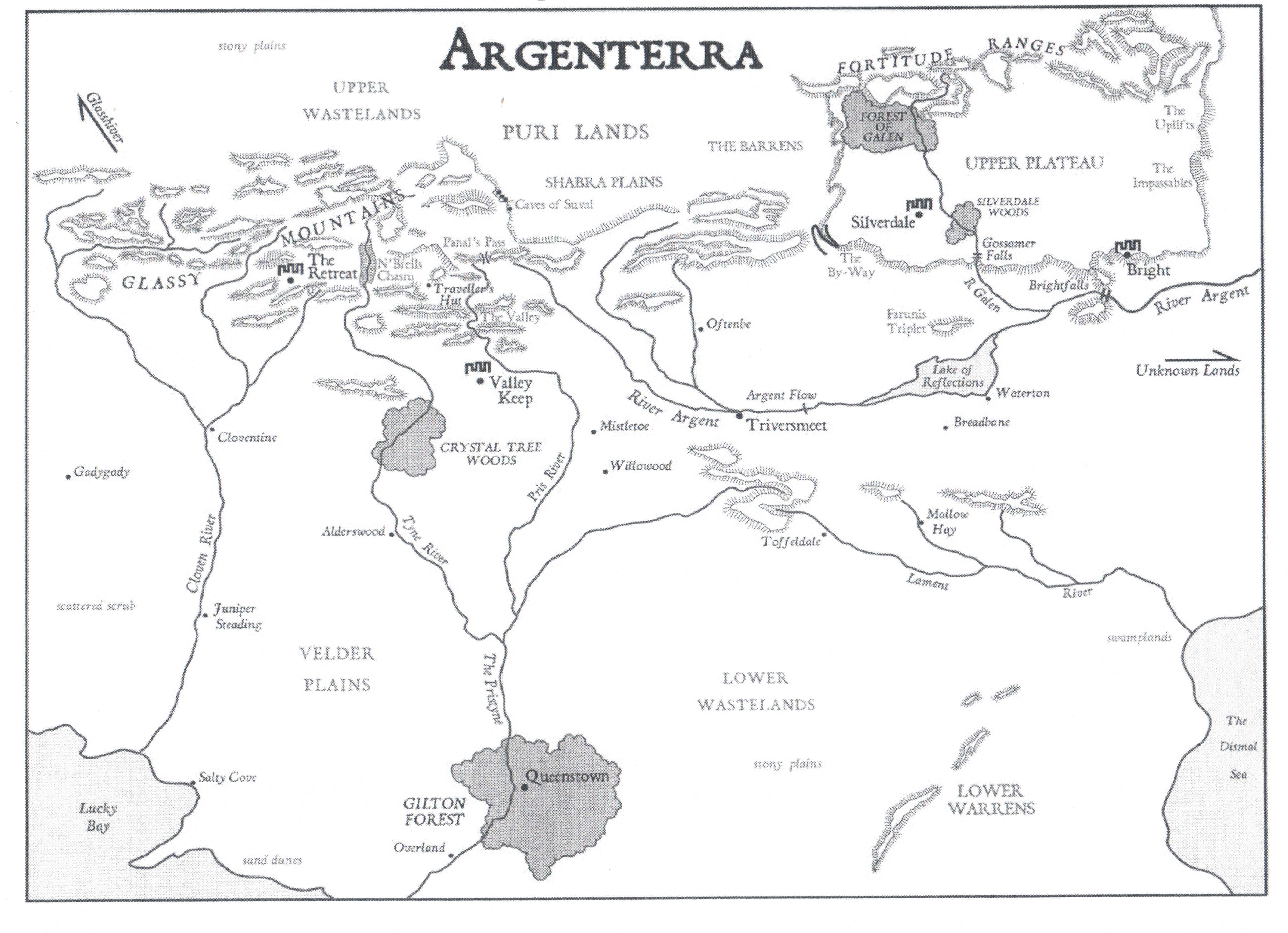
The map helped me navigate the land in the Silverlands series and he sat with me to talk about naming conventions and how languages changed over time. I had a place called Two Rivers Meet and he said that it would be better as Trivers Meet or something similar. He also talked about some place names and from whose perspective they were named from. It was an incredibly helpful discussion and he also helped me flesh out a few things about the geography. He also prompted me to give the place a few more names so it wasn’t just empty in places. I also had the Lake of Reflections drawn way to big!

This is the map of Argenterra he did for me, based on my drawing but with extensive Russell improvements.

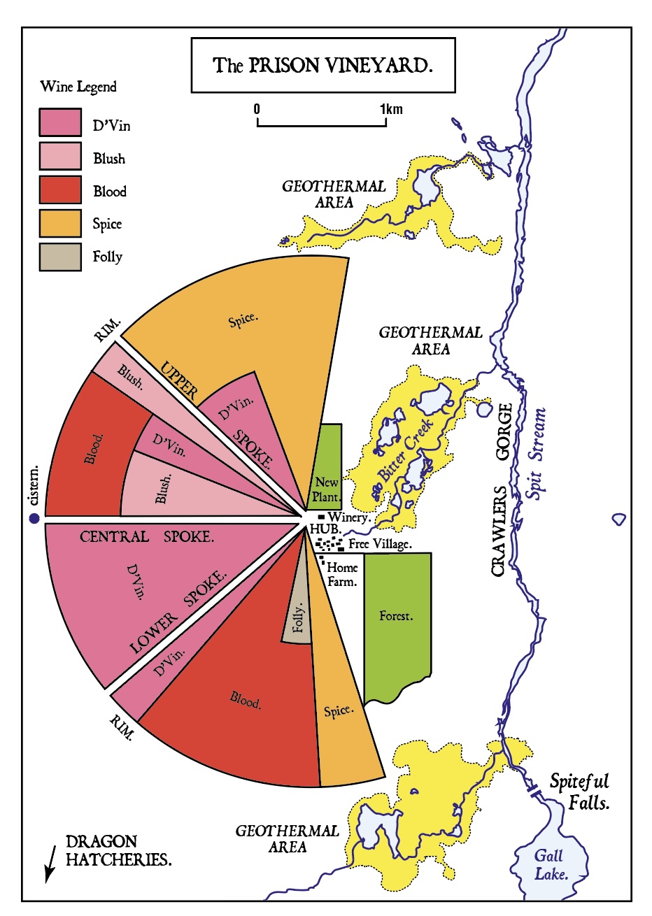
The next set of maps we worked on were Dragon Wine maps, three in total. It wasn’t a matter of just handing him a rough drawing. No, I had to sit with him and learn stuff too. Dragon Wine opens in Shatterwing at the prison vineyard and this is how we envisioned it. It was Russell’s idea to have the vineyard broken into types of grapes and we also had fun naming the rivers and things to fit in with what I had mentioned in the book. This map was included in the Pan Macmillian version of the book but somehow slipped out of my self published version. I’ll be fixing that soon.

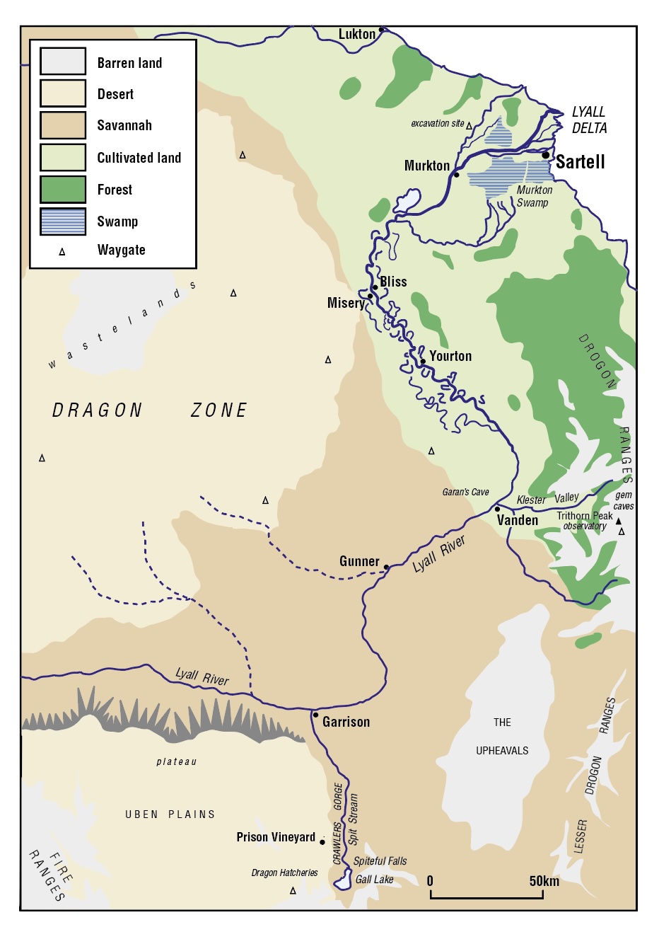
The other map pertinent to the first and second books, Shatterwing and Skywatcher, is the map of the Sartell region. They also work for Nightwings and Bloodstorm. It also shows where the prison vineyard is, where the observatory is and Vanden town as well as Sartell. Some of these places are explored in the rest of the series.

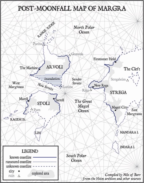
For the last two books, I needed a map of the whole world of Margra. As it was post-apocalyptic, after a moon fell, there would be significant changes compared to the past, which is unknown. The map needed to be a sort of pieced together map that identifies past continents, swamped shorelines and maybe even conjecture. Russell did a bit of research on this and also drew on past experience of seeing maps where things were guestimated rather than measured and so on.

So for Skyfire and Moonfall, we have a different map. I love the little note at the bottom saying it was compiled by Nils of Barr. Sitting with Russell to do this was not easy because I had to have the names of all the things I referenced and then explain them to Russell. Some are just mentioned in reference to pre-Shatterwing and are not actually travelled during the story. I think Russell wanted to educate me but I can’t replace him with regards to maps. Some people are just good at visualising. Me not so much.

If I do maps in the future, well not sure how that is going to go. I use sketches of houses and things to navigate and describe but not publish them.

Russell thank you for helping me envisage worlds. You taught me so much but I have a lot to learn still.

Read Full Post »

The final installment in the Dragon Wine series is fast approaching. Due date 31 August 2018.

The proof corrections have arrived and I’ve started on them.

Also, the  map, which I’m going to share here.

But first! I’d share the blurb but I may have to change it.

Moonfall-highres(1)

Buy Links

amazon Google Kobo ibooksNook

Now for the map. I had drawn this out but in discussion with Dr Russell Kirkpatrick about the map, he came up with this very cool idea. He is a geographer as well as a writer, Legoman and golf/sport/music nerd. He had been looking at some historical maps of New Zealand from when not much had been explored. The map we looked at (and he did tell me who it was by) showed rumoured coastline and unknown coastlines (or not-just unknown blank space). Anyway, we thought this would work well for the map of Margra because it’s a post-apocalyptic world and the coastlines of the continents had changed, and civilisation had been devastated and once thriving cities ruined. So we came up with this, mostly Russell came up with this. I’d love to hear what you think.

This is meant to be the map that Nils puts together from his research in the Hiem archives and from hearing accounts from Danton and Brill. The map will appear in Moonfall, print and ebooks.

Margra World Map Moonfall 2


Read Full Post »